


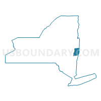
Rensselaer County--Troy City PUMA, New York
About
Outline

Summary
| Unique Area Identifier | 193522 |
| Name | Rensselaer County--Troy City PUMA |
| State | New York |
| Area (square miles) | 665.39 |
| Land Area (square miles) | 652.43 |
| Water Area (square miles) | 12.96 |
| % of Land Area | 98.05 |
| % of Water Area | 1.95 |
| Latitude of the Internal Point | 42.71042060 |
| Longtitude of the Internal Point | -73.51384540 |
Maps

Graphs
Select a template below for downloading or customizing gragh for Rensselaer County--Troy City PUMA, New York


Neighbors
Neighoring Public Use Microdata Area (by Name) Neighboring Public Use Microdata Area on the Map
- Albany County (East Central)--Albany City PUMA, NY
- Albany County (Outside Albany City) PUMA, NY
- Berkshire County--Pittsfield City PUMA, MA
- Columbia & Greene Counties PUMA, NY
- Saratoga County (Outer) PUMA, NY
- Saratoga County (South & Central) PUMA, NY
- Southwest Vermont--Rutland, Bennington & Addison Counties PUMA, VT
- Warren & Washington Counties PUMA, NY
Top 10 Neighboring County (by Population) Neighboring County on the Map
- Albany County, NY (304,204)
- Saratoga County, NY (219,607)
- Rensselaer County, NY (159,429)
- Berkshire County, MA (131,219)
- Washington County, NY (63,216)
- Columbia County, NY (63,096)
- Greene County, NY (49,221)
- Bennington County, VT (37,125)
Top 10 Neighboring County Subdivision (by Population) Neighboring County Subdivision on the Map
- Albany city, Albany County, NY (97,856)
- Colonie town, Albany County, NY (81,591)
- Troy city, Rensselaer County, NY (50,129)
- Bethlehem town, Albany County, NY (33,656)
- Halfmoon town, Saratoga County, NY (21,535)
- East Greenbush town, Rensselaer County, NY (16,473)
- Cohoes city, Albany County, NY (16,168)
- Bennington town, Bennington County, VT (15,764)
- Schodack town, Rensselaer County, NY (12,794)
- North Greenbush town, Rensselaer County, NY (12,075)
Top 10 Neighboring Place (by Population) Neighboring Place on the Map
- Albany city, NY (97,856)
- Troy city, NY (50,129)
- Cohoes city, NY (16,168)
- Watervliet city, NY (10,254)
- Rensselaer city, NY (9,392)
- Mechanicville city, NY (5,196)
- East Greenbush CDP, NY (4,487)
- Menands village, NY (3,990)
- Hoosick Falls village, NY (3,501)
- Wynantskill CDP, NY (3,276)
Top 10 Neighboring Elementary School District (by Population) Neighboring Elementary School District on the Map
- Bennington Incorporated School District, VT (14,121)
- Williamstown School District, MA (7,754)
- Pownal School District, VT (3,527)
- Shaftsbury School District, VT (2,853)
- Hancock School District, MA (717)
Top 10 Neighboring Secondary School District (by Population) Neighboring Secondary School District on the Map
- Mount Anthony Union High School District 14, VT (23,305)
- Mount Greylock School District, MA (11,073)
- Mount Greylock/New Lebanon (NY) School Districts in Hancock (7-12), MA (717)
Top 10 Neighboring Unified School District (by Population) Neighboring Unified School District on the Map
- Albany City School District, NY (97,839)
- Troy City School District, NY (40,880)
- East Greenbush Central School District, NY (29,561)
- Bethlehem Central School District, NY (27,878)
- Averill Park Central School District, NY (19,313)
- Lansingburgh Central School District, NY (17,151)
- Cohoes City School District, NY (16,168)
- Ravena-Coeymans-Selkirk Central School District, NY (14,064)
- Kinderhook Central School District, NY (13,856)
- Watervliet City School District, NY (11,009)
Top 10 Neighboring State Legislative District Lower Chamber (by Population) Neighboring State Legislative District Lower Chamber on the Map
- Assembly District 109, NY (139,831)
- Assembly District 112, NY (139,495)
- Assembly District 106, NY (134,254)
- Assembly District 108, NY (131,716)
- Second Berkshire District, MA (40,125)
- First Berkshire District, MA (35,916)
- Bennington-2-1 State House District, VT (7,997)
- Bennington-1 State House District, VT (3,951)
- Bennington-3 State House District, VT (3,598)
Top 10 Neighboring State Legislative District Upper Chamber (by Population) Neighboring State Legislative District Upper Chamber on the Map
- State Senate District 43, NY (322,103)
- State Senate District 41, NY (316,491)
- State Senate District 45, NY (306,856)
- State Senate District 46, NY (304,204)
- State Senate District 51, NY (296,420)
- Berkshire, Hampshire & Franklin District, MA (149,418)
- Bennington State Senate District, VT (39,001)
Top 10 Neighboring 111th Congressional District (by Population) Neighboring 111th Congressional District on the Map
- Congressional District 20, NY (683,198)
- Congressional District 21, NY (679,193)
- Congressional District 1, MA (644,956)
- Congressional District (at Large), VT (625,741)
Top 10 Neighboring Census Tract (by Population) Neighboring Census Tract on the Map
- Census Tract 136.01, Albany County, NY (9,372)
- Census Tract 524.04, Rensselaer County, NY (7,341)
- Census Tract 523.04, Rensselaer County, NY (6,979)
- Census Tract 524.03, Rensselaer County, NY (6,927)
- Census Tract 516, Rensselaer County, NY (6,764)
- Census Tract 620, Saratoga County, NY (6,618)
- Census Tract 627, Saratoga County, NY (6,433)
- Census Tract 525.01, Rensselaer County, NY (6,290)
- Census Tract 4.02, Columbia County, NY (6,142)
- Census Tract 520.04, Rensselaer County, NY (6,005)
Top 10 Neighboring 5-Digit ZIP Code Tabulation Area (by Population) Neighboring 5-Digit ZIP Code Tabulation Area on the Map
- 12180, NY (53,606)
- 12144, NY (20,555)
- 12047, NY (19,664)
- 12189, NY (17,568)
- 05201, VT (14,851)
- 12182, NY (14,733)
- 12118, NY (13,897)
- 12188, NY (10,980)
- 12202, NY (9,628)
- 12061, NY (9,050)